
Numerical Modeling
CAMERI has great experience in numerical modeling in the field of waves, hydrodynamics, bathymetric analysis, sediment transport, beach morphology, and more.
The numerical modeling results are critical for different aspects of planning.
Areas of Specialization
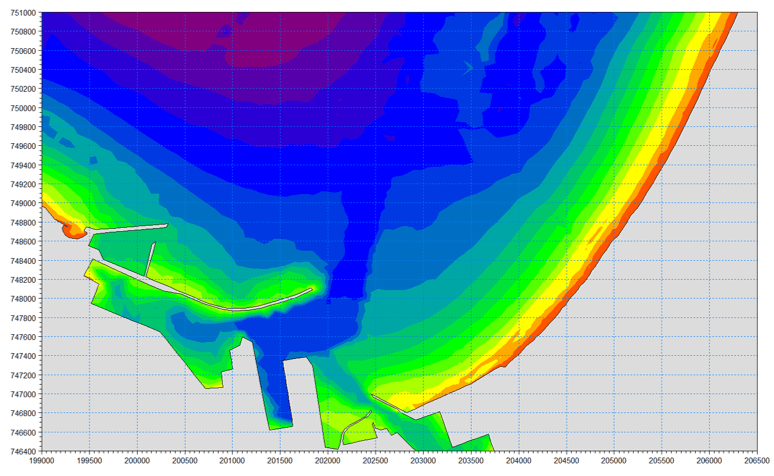
Coastal facilities and human activities such as dredging can significantly impact sediment transport dynamics along the shore. Shoreline morphological changes might increase the risk for pumping and piping, erosion and flooding, harm local wildlife, and compromise other coastal facilities.
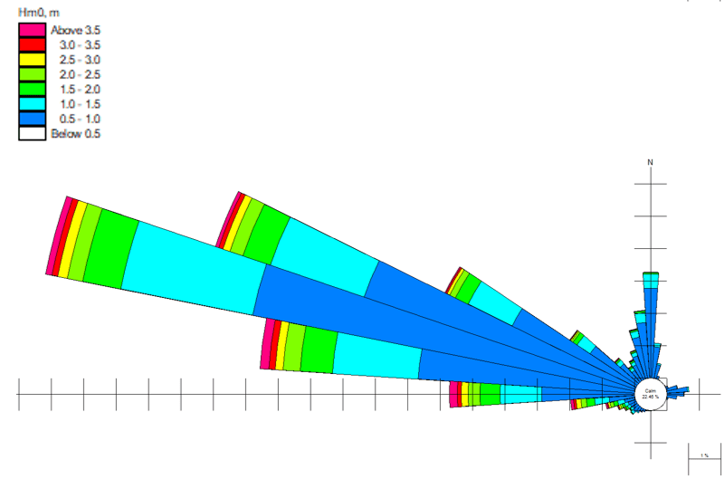
Almost all the shoreline of Israel is sandy. Israeli coastal sands originate primarily from the River Nile delta. The annual gross transport along the Israeli coast is approximately 300,000-400,000 m3/yr. Net transport rates varies between ~200,000 m3/yr (Ashdod) and ~80,000 m3/yr (Haifa).
CAMERI stands at the forefront of enabling continued environmentally sustainable development of Israeli coastal regions:
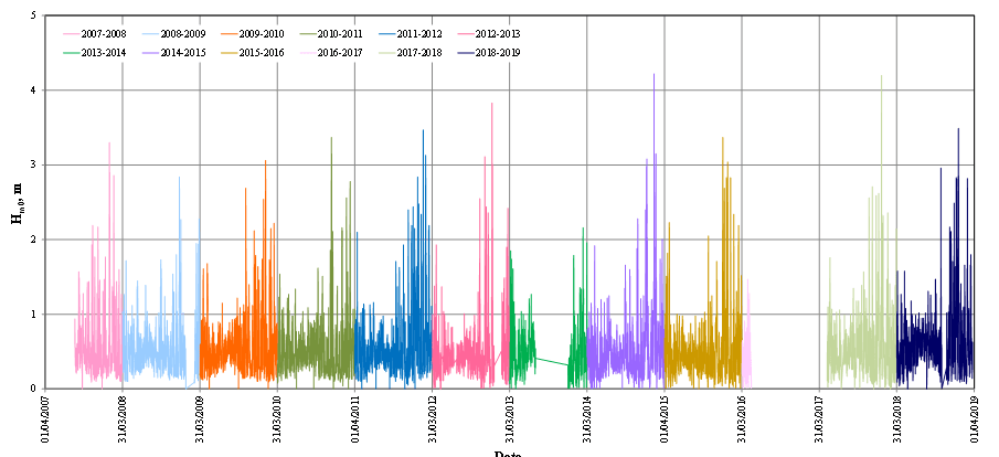
- Conducting morphological changes and coastline evolution studies along the Israeli coast. The studies provide hindcast and forecast numerical modeling, accounting for natural phenomena and potential consequences of human activity on sediment transport patterns.
- Providing mandatory environmental impact assessments for coastal and marine enterprises.
- Analyzing and developing recommendations for countermeasures to beach erosion.
The Sea Water Reverse Osmosis (SWRO) desalination program in Israel is comprised of five facilities, providing
673×106 m3/yr of potable water. The production process of desalinated water entails environmental and engineering challenges on the incoming/outgoing streams:
- Discharge of brine, heavy metals, and toxic chemical compounds which jeopardize marine life and flora. Dilution and spreading solutions require modeling to ensure their effectiveness.
- Robustness of intake and outfall systems – Ensuring that water pumped into the plant does not contain brine or chemicals that can compromise the efficiency of the work process, the equipment, and the water quality.
CAMERI has provided the brine dispersion models for all of the desalination plants on the Israeli Mediterranean coast. In addition, CAMERI has modeled and analyzed the concentrations of pollutants in the vicinity of various desalination intakes.
Coastal facilities such as power plants rely on seawater for the removal of surplus heat from the core. However, ensuring that the discharged hot water does not circulate back to the intake for efficient operation is essential.
CAMERI specializes in cooling water recirculation and dispersion modeling in conjuncture with desalination brine, chemical discharges, etc.
Most marine engineering applications combine fluid, geotechnical, and structural dynamics. In CAMERI, we use CFD tools to model and predict:
- fluid-structure-interactions on wave-energy converters, marine vessels, coastal defense structures, offshore rigs, etc.
- Fluid-soil-interactions phenomena such as pile and fence scouring, spill-way scouring, etc.
FSI problems require substantial computational resources. CAMERI has access to Technion’s ZEUS cluster. ZEUS comprises 24 nodes (totaling 940 cores), utilizing 9216 GB with 200GBps InfiniBand connectivity.
Estimating and controlling the environmental impact of anthropogenic and industrial pollutants such as open-water fisheries and municipal sewage discharge on coastal regions is crucial.
CAMERI is equipped with state-of-the-art numerical tools for 2D and 3D ecological modeling, capable of simulating the spatial distribution fate of passive and active species concentrations inconjuncture with hydrodynamic dispersion.
Simulation Tools
MIKE by DHI is a range of software products to accurately analyze, model, and simulate any type of challenge in water environments.
Delft3D FM is a modeling environment for the simulation of among other things storm surges, that shows local flows and water levels, waves, sediment transport, and more. XBeach is a model used for the computation of nearshore hydrodynamics and the morphodynamical response during storm events.
A numerical model to calculate shoreline change, wave-induced long-shore sand transport, and morphology change at inlets on a local to regional scale. GenCade is operated within the Surface-water Modeling System Interface bringing functionality to a georeferenced environment.
EPA is an application for simulating surface water jets and plumes provided by the United States Environmental Protection Agency.
Developed by a European consortium of governmental and private organizations, TELEMAC is an integrated suite of solvers for use in the field of free-surface flows. Telemac can be used to study and model various transport phenomena in coastal regions, rivers, and lakes.
CAMERI3D/HD-ST is a Hydrodynamic and sediment transport simulation model developed by CAMERI.
SWASH (Simulating WAves till SHore) is a non-hydrostatic, RANS (Reynolds Averaged Navier Stokes) type wave-flow model. The solver is used for predicting surf zone and swash zone dynamics, agitation in ports and harbors, rapidly varied shallow water flows (e.g., dike breaks, tsunamis, and flood waves), and density–driven flows.
OpenFOAM (Open Source Field Operation and Manipulation) is a library of continuum mechanics solvers (i.e., fluid and solid body dynamics). In CAMERI, OF is used to study and model Fluid-Solid Interactions of floating structures and marine vessels, buoyant turbulent–jet flows such as desalination and power plant outfalls.
CAMERI researchers use Technion’s ‘ZEUS’ HPC cluster. ZEUS is comprised of 24 nodes (totaling 940 cores), utilizing 9216 GB with 200GBps InfiniBand connectivity.
Surfer by Golder Software is a powerful contouring, gridding, and surface mapping package.